Near-Real-Time Turbidity Monitoring at Global Scale Using Sentinel-2 Data and Machine Learning Techniques Masuma Chowdhury, Ignacio de la Calle, Irene Laiz, Ana B. Ruescas Remote Sensing, 2025 Reliable global turbidity monitoring is crucial for water resource management, yet existing satellite-based methods face limitations in accuracy, generalization, and scalability across diverse aquatic environments. This study presents a robust, globally applicable turbidity estimation model using Sentinel-2 imagery and a machine-learning approach, developed based on harmonized global open-source datasets (GLORIA and MAGEST; turbidity range: 0–2200 FNU) encompassing 68 lakes, 2 rivers, 2 estuaries, and 11 coastal oceans across 17 countries. Among the evaluated machine-learning models, gradient boosting regression demonstrated the best performance, achieving a high correlation (r: 0.95) with minimal bias (1.32 FNU) and robust generalization across all water types, outperforming existing turbidity models when evaluated on the same test dataset. Shapley Additive exPlanations-based model interpretability identified the Rrs865/Rrs560 ratio as the dominant predictor, with critical contributions from Rrs783, Rrs665, and Rrs865. The model’s performance is evaluated across various optical water types and aquatic systems in diverse geographical settings, showcasing its robustness in sediment-rich and highly turbid environments that underscores its suitability for reliable turbidity monitoring after severe storms or extreme precipitation. Additionally, innovative automated pipelines integrated within a scientific exploitation platform facilitate scalable and near-real-time operational monitoring. This methodological integration provides a significant advancement in satellite-based turbidity monitoring, enabling informed water quality management under diverse environmental and climatic conditions.
Unraveling the environmental drivers of blue whiting recruitment: 20 years of observations Irene Laiz, Masuma Chowdhury, Gonzalo González-Nuevo, Francisco Velasco, Francisco Baldó Frontiers in Marine Science, 2025 Recruitment in marine fish is a complex process influenced by multiple ecological factors that often interact in unpredictable ways, making reliable forecasting challenging. Environmental variability further amplifies this uncertainty. This study analyzed the abundance of 0-year class blue whiting (Micromesistius poutassou) from the Spanish bottom trawl survey on the Porcupine Bank (Irish shelf) between 2001 and 2020, focusing on the exceptional recruitment event in 2020. We examined the effects of wind, chlorophyll-a concentration, salinity, temperature, and ocean currents during the spawning season, along with the spawning stock biomass (SSB). Results indicate that recruitment was primarily influenced by the wind-mixing index, chlorophyll-a concentration, and retention index, with no significant correlation to SSB. Although interannual variability in both environmental conditions and recruitment was high, the relationship between environmental factors and recruitment was not always predictable. For instance, while warm and saline years are generally associated with higher recruitment, the period 2002-2012 (characterized by warm and saline waters) only showed strong recruitment in 2003, 2004, 2007, 2009, and 2010. Conversely, although cold and low-salinity conditions are typically linked to lower recruitment, 2020 saw very strong recruitment despite the below-average SSB. Our findings suggest that the exceptional recruitment in 2020 resulted from a unique combination of favorable conditions. Unusually low wind conditions triggered the formation of a stable Taylor column circulation over the Porcupine Bank, promoting phytoplankton accumulation, as evidenced by the elevated chlorophyll-a concentrations. This likely increased food availability for larvae, while the Taylor column also acted as a retention mechanism for larvae and prey. Lagrangian simulations supported this retention hypothesis. Additionally, temperature and salinity conditions during the 2020 spawning season likely optimized the ascent of early life stages from spawning depths to the food-rich surface waters, improving larval feeding success and contributing to the historical recruitment event.
AI-driven remote sensing enhances Mediterranean seagrass monitoring and conservation to combat climate change and anthropogenic impacts Masuma Chowdhury, Alejo Martínez-Sansigre, Maruška Mole, Eduardo Alonso-Peleato, Nadiia Basos, et al. Scientific Reports, 2024 Seagrasses are undergoing widespread loss due to anthropogenic pressure and climate change. Since 1960, the Mediterranean seascape lost 13–50% of the areal extent of its dominant and endemic seagrass-Posidonia oceanica, which regulates its ecosystem. Many conservation and restoration projects failed due to poor site selection and lack of long-term monitoring. Here, we present a fast and efficient operational approach based on a deep-learning artificial intelligence model using Sentinel-2 data to map the spatial extent of the meadows, enabling short and long-term monitoring, and identifying the impacts of natural and human-induced stressors and changes at different timescales. We apply ACOLITE atmospheric correction to the satellite data and use the output to train the model along with the ancillary data and therefore, map the extent of the meadows. We apply noise-removing filters to enhance the map quality. We obtain 74–92% of overall accuracy, 72–91% of user’s accuracy, and 81–92% of producer’s accuracy, where high accuracies are observed at 0–25 m depth. Our model is easily adaptable to other regions and can produce maps in in-situ data-scarce regions, providing a first-hand overview. Our approach can be a support to the Mediterranean Posidonia Network, which brings together different stakeholders such as authorities, scientists, international environmental organizations, professionals including yachting agents and marinas from the Mediterranean countries to protect all P. oceanica meadows in the Mediterranean Sea by 2030 and increase each country’s capability to protect these meadows by providing accurate and up-to-date maps to prevent its future degradation.
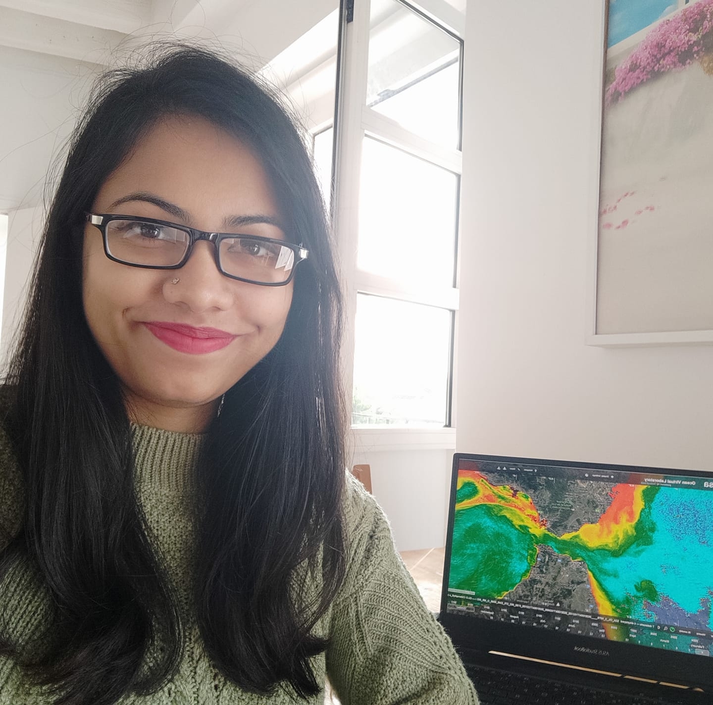
Monitoring turbidity in a highly variable estuary using Sentinel 2-A/B for ecosystem management applications Masuma Chowdhury, César Vilas, Stef van Bergeijk, Gabriel Navarro, Irene Laiz, et al. Frontiers in Marine Science, 2023 The Guadalquivir estuary (southern Spain) occasionally experiences medium to high turbidity, reaching above 700 Formazin Nephelometric Unit (FNU) during extreme events, thus negatively influencing its nursery function and the estuarine community structure. Although several turbidity algorithms are available to monitor water quality, they are mainly developed for mapping turbidity ranges of 0-100 FNU. Thus, their use in a highly turbid region may not give accurate results, which is crucial for estuarine ecosystem management. To fill this gap, we developed a multi-conditional turbidity algorithm that can retrieve turbidity from 0 to 600 FNU using the Sentinel-2 red and red-edge bands. Four major steps are implemented: atmospheric and sun glint correction of the Level-1C Sentinel-2 data, spectral analysis for different water turbidity levels, regression modelling between in situ turbidity and remote sensing reflectance (Rrs) for algorithm development, and validation of the best-suited model. When turbidity was < 85 FNU, the Rrs increased firstly in the red wavelength (665 nm), but it saturated beyond a certain turbidity threshold (> 250 FNU). At this time, Rrs started to increase in the red-edge wavelength (704 nm). Considering this spectral behavior, our algorithm is designed to automatically select the most sensitive turbidity vs. Rrs, thus avoiding the saturation effects of the red bands at high turbidity levels. The model showed good agreement between the satellite derived turbidity and the in situ measurements with a correlation coefficient of 0.97, RMSE of 15.93 FNU, and a bias of 13.34 FNU. Turbidity maps derived using this algorithm can be used for routine turbidity monitoring and assessment of potential anthropogenic actions (e.g., dredging activities), thus helping the decision-makers and relevant stakeholders to protect coastal resources and human health.
Potential Impacts of Industrialization on Coastal Fresh Groundwater Resources in Bangladesh Mahfuzur R Khan, Fuad Hasan, Majidul Islam, Masuma Chowdhury, Sumiya Sadeak, et al. Sustainability Switzerland, 2022 Bangladesh is overly dependent on groundwater and the demand in the near future is expected to increase, as the country is experiencing rapid development and industrial growth. This study assesses the prospect and sustainability of groundwater in Mirsharai Upazila, Chattogram, where a large industrial area, namely ‘Bangabandhu Sheikh Mujib Shilpa Nagar (BSMSN)’, is taking shape. The physical aquifer system was characterized and groundwater quality was mapped. There is one thick aquifer in the northernmost part of the upazila, which splits into three separate aquifers in the south. Water quality indexing suggests that the deep (>130 m) groundwater throughout upazila is good (n = 5) to excellent (n = 18), while the shallow groundwater is mostly poor to unsuitable for both drinking and irrigation purposes. Because of the close proximity to the sea and the presence of thick clays above the deep freshwater aquifer in the BSMSN area, heavy industrial abstraction poses a threat to the lateral intrusion of seawater and land subsidence. Even a small subsidence in the project area at only a couple of meters above sea level would jeopardize the entire project. This study recommends limiting the use of the deep fresh groundwater for the current population of the upazila.